
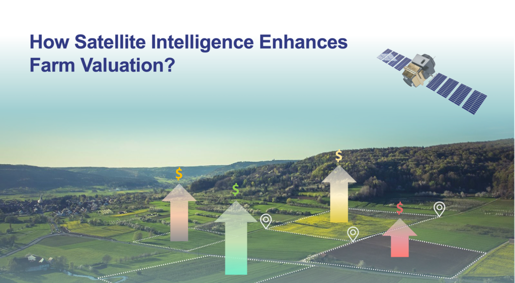
Introduction
In the world of agriculture, accurately valuing farmland is a complex but crucial task. Traditional methods often rely on basic information such as location and land size, which, while important, do not provide a comprehensive picture. Agronomic factors, including arable and tillable acreage, productivity history, soil conditions, and environmental risks, play a critical role in determining actual land value. Obtaining this detailed information can be challenging, but advancements in satellite imagery technology have revolutionized the process. By leveraging satellite intelligence, farm appraisers and professionals can gain deeper insights into farmlands, enhancing the accuracy of valuations and helping stakeholders make informed decisions.
The Role of Satellite Imagery in Farm Valuation
Satellite imagery provides a wealth of information that traditional maps and documents cannot. This technology offers detailed views of farmlands, revealing essential factors such as arable and tillable acres, land use, topography, soil properties, weather patterns, and environmental risks. By incorporating these data points, farm appraisers can perform more precise valuations, ensuring that all aspects of the land are considered.
Key Satellite-Driven Factors for Farm Appraisal
Land Size and Use
Satellite imagery helps determine the exact size of a land parcel and its current use. This information is crucial for understanding the potential and limitations of the farmland. Accurate land use data can highlight areas suitable for cultivation, grazing, or conservation.
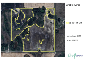
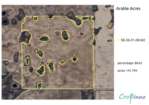
Arable and Tillable Acres
Differentiating between arable and tillable acres is essential for farm assessments. Arable land refers to the total area suitable for cultivation, while tillable acres denote the portion actively cultivated. Satellite imagery allows for precise measurement of these areas, providing a clearer picture of the land’s practical utility.
Topography
The topography of farmland, including slope and elevation, significantly impacts its usability and productivity. Satellite data offers detailed topographical maps, helping appraisers understand the land’s physical characteristics and potential challenges.
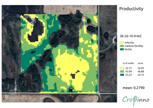
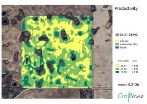
Productivity
Productivity maps generated from satellite data highlight high and low productivity zones within a farm. These maps are based on historical crop performance and soil fertility, offering insights into the land’s capacity to support various crops. This information is invaluable for determining the economic potential of the farmland.
Crop Rotation
Satellite imagery can track historical crop rotation patterns, providing insights into soil health and fertility. Crop rotation improves soil structure and reduces the risk of pests and diseases, which can enhance long-term productivity.
Crop Stress
Identifying crop stress is crucial for assessing the resilience and management practices of a farm. Satellite images can detect signs of stress caused by factors such as water deficiency, pest infestations, and nutrient imbalances. Understanding these issues helps appraisers evaluate the land’s overall health and productivity.
Soil Properties
Soil texture, moisture, and carbon storage are key factors influencing farmland value. Satellite data provides detailed information on soil composition, helping appraisers assess its suitability for different crops. Soil carbon storage also has implications for environmental sustainability and potential revenue from carbon credits.
Weather Data
Weather patterns, including precipitation and temperature, directly impact crop growth and yield. Satellite imagery offers historical and real-time weather data, enabling appraisers to evaluate the farm’s climate resilience and predict future productivity.
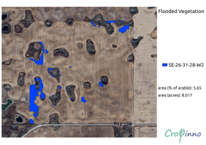
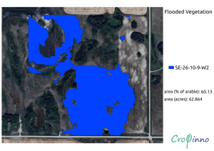
Flood and Drought Risk
Assessing environmental risks such as flooding and drought is essential for farm valuation. Satellite data helps identify areas prone to these risks, providing critical information for risk management and insurance purposes.
Benefits of Satellite Intelligence in Farm Valuation
Accuracy
Satellite imagery provides high-resolution, up-to-date information, significantly enhancing the accuracy of farm appraisals. This precision helps stakeholders make well-informed decisions about purchasing, leasing, or investing in farmland.
Efficiency
Satellite data collection is faster and more efficient than traditional methods. It allows for comprehensive analysis of large areas without the need for extensive on-ground surveys, saving time and resources.
Comprehensive Analysis
By integrating multiple data points, satellite imagery offers a holistic view of farmland. This comprehensive analysis includes physical, agronomic, and environmental factors, ensuring a thorough assessment of the land’s value.
Environmental Insights
Understanding environmental conditions and risks is crucial for sustainable farming practices. Satellite data provides detailed information on soil health, weather patterns, and ecological impacts, promoting environmentally responsible decision-making.
Conclusion
Satellite intelligence is revolutionizing farm valuation by providing detailed, accurate, and comprehensive data. This technology enables farm appraisers and agricultural professionals to make more realistic and precise assessments, ensuring that all relevant physical, agronomic, and environmental factors are considered.
At Cropinno, we specialize in providing essential insights for farm valuation. Whether you’re an appraiser looking to enhance your services or someone interested in buying or renting a farm, our expertise can guide your decision-making process.
Contact us at [email protected] to schedule a demo and discover how we can help you understand the true value of your farmland investments.