
First things first; Are you familiar enough with precision agriculture?
Precision agriculture (farming) is a new definition in the field. Nowadays, the concern of increasing the yield of agricultural lands per unit area has led humans to use new methods in farm management, methods that will lead to optimizing input utilization, improving crop quality, improving the efficiency of chemical material and also environmental protection. Precision farming is a modern, knowledge-based approach in which satellites, sensors, maps, and remote sensing data help the farmer increase the accuracy of his practice. The range of possibilities that this method brings is so great that it may be considered a great revolution in the agricultural industry and a path toward the future.
And now we will take a closer look at one of the most important factors that is studied in precision agriculture: The climate change.
Climate change & Global warming
Among the major factors that affect the agricultural process is climate change. The ups and downs in climate and global warming are among the most important issues in the world today, and the various effects they have on human activities, such as agriculture, can be seen anywhere on earth. But what exactly are the impacts of climate change on agriculture?
Climate changes, such as reduction in seasonal rainfall, has changed the way crops are grown. Many rainfed cultivated lands have been affected and destroyed and as a result, farmers are turning to irrigated crops, which has led to an increase in uncontrolled consumption of water and groundwater resources, a decrease in groundwater levels and a negative water balance in wells. The changes also have a direct (increasing) effect on unemployment rate in the agriculture career field. An increase in temperature during the growing season has a negative effect on the yield of many crops and orchards, as the results of researches made in this area show that for one degree of temperature increase, the yield per hectare decreases by 0.38%.
Meteorological factors have a significant impact on agricultural operations. Even the distribution (degree and level of dispersion) of crop species at different latitudes and altitudes is closely related to meteorological factors, especially rainfall and temperature.
Rising average temperatures, changes in the pattern, distribution of rainfall, and changes in the amount of radiation entering the soil surface are what’s referred to as the climate change in recent years across the globe. These factors have led to changes in plant species diversity and interspecific competitiveness, geographical distribution, and the invasive power of pests and weeds in cropping systems. Due to climate change, in order to be able to have maximum agricultural efficiency in each region, it is necessary to study the meteorological and environmental factors of that region before any planning or action.
See the drought from afar!
How much information will be available to us about the Earth’s climatic conditions and events by using the Remote Sensing technology? Satellites that have been launched into space for remote sensing purposes aid researchers and experts in weather detection, calculating the amount of radiation that enters vegetation, the amount of rainfall, the detection of fires & droughts, phenomena related to the melting of polar ice, forest changes, etc. In agriculture, Using remote-sensing satellites helps to determine the amount of rainfall in an area and examine its environmental factors, by which the necessary measures can be taken to better manage a farm.
One of the global issues that affects many countries today is the issue of droughts. With a lack of rainfall and the influence of other meteorological parameters such as strong winds and a decrease in relative humidity, which intensifies the drought, the vegetation in each area decreases. From a remote sensing perspective, drought can be studied by spectral changes in satellite imagery due to changes in vegetation and surface moisture conditions.
There are multiple definitions or types, to be precise, of droughts: Meteorological drought, Agricultural drought and Hydrological drought.
The “Meteorological drought” occurs when arid climates prevail in areas. “Hydrological drought” is a situation in which there is evidence of depletion of water resources, especially surface water and groundwater, and “Agricultural drought” occurs when crops become affected by drought. To study meteorological drought, air temperature and rainfall are two important and primary parameters, and to study agricultural drought, soil moisture and groundwater level are vital and decisive.
How does the satellite predict drought?
We know that satellites can examine certain indicators in the agricultural debate. One of these important indicators that shows the response of vegetation to the phenomenon of drought is the “Vegetation Condition Index (VCI)”.
An Indian researcher and professor, Dipanwita Dutta, and colleagues in the Department of Remote Sensing and GIS at Vidyasagar University conducted a study on the relationship between vegetation condition index (VCI) and two other indicators: standardized precipitation index (SPI) and rainfall anomaly index (RAI). This relationship shows that by examining the indices obtained from meteorological data, it is possible to predict the drought of an area and the effect of drought on the agricultural lands of that area. Fortunately, satellites give us the required data. So, by using the remote-sensing functions of satellites and calculations based on their data, we may know if a field is heading towards drought or which area cannot be cultivated; the result will be better management of water resources and saving a lot of related costs.
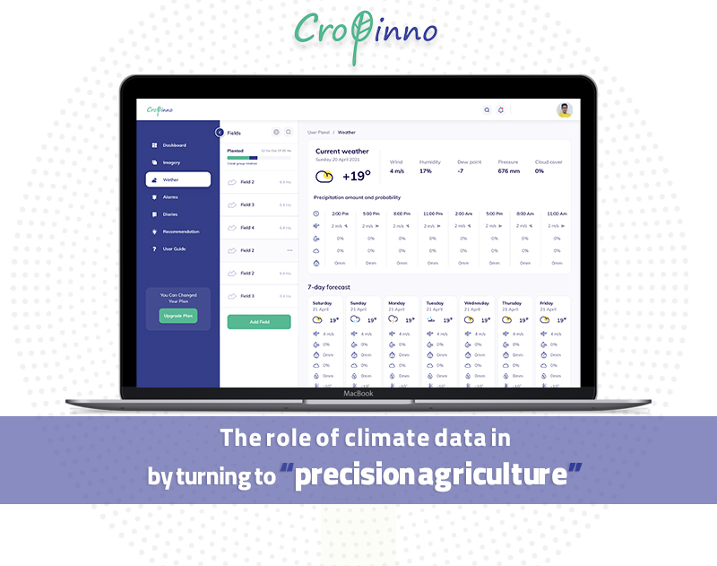
Cropinno, collects meteorological information of each region from the nearest meteorological station to that region and provides farmers with accurate and useful data such as weather effects, rainfall, dew point, and the weather forecast for the next 7 days. The next step is when our experts at Cropinno analyze this information and notify our farmer friends about the necessary tips and recommendations (on time) for better planning and management of an agricultural land.
To better understand the impact of climate factors on agriculture, see a picture from the panel of one of our clients:
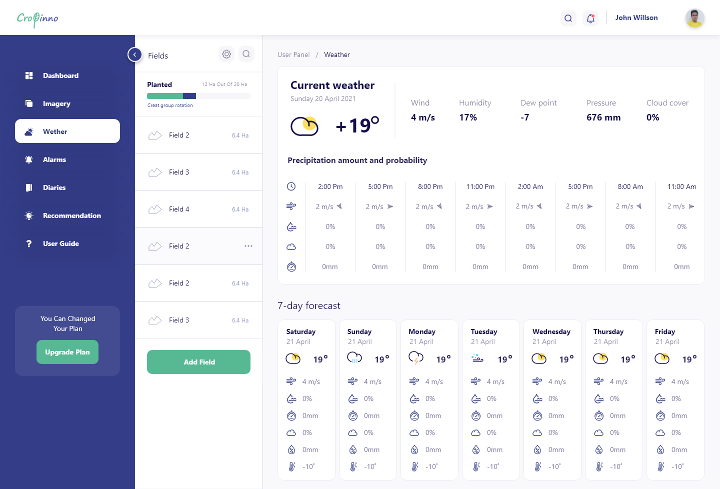
In the figure above, we see what information is provided to the user in the meteorological section of Cropinno farm management platform and we also observe the weather condition effects on agricultural practices at different stages of planting and harvesting.
If you own a farm or work in agriculture, you can register right now and benefit from this feature and many more, to cut your costs, increase your yield and manage your farm at best.