To learn more
about how we can support your appraisal and valuation needs
Cropinno provides cutting-edge data solutions to support appraisers, lenders, investors, and others in the farm valuation industry. By leveraging advanced satellite imagery, AI technology, and historical data, we offer detailed insights into farmland characteristics, enabling accurate and reliable valuations. Whether you are conducting an appraisal, evaluating investments, or assessing risks, our service ensures you have the data you need for informed decisions.

Identify flood-prone areas through satellite data and historical flood analysis. This risk evaluation helps appraisers account for potential environmental impacts on land value and guide stakeholders in mitigation planning.
Analyze long-term drought patterns to assess the land’s resilience and water management needs. This data supports appraisers in evaluating risks and sustainability factors in farmland valuation.
Track changes in land cover over time to understand shifts in land use and management practices. This information is critical for assessing the sustainability and evolving value of agricultural properties.
Gain a clear understanding of land usage with our satellite technology. We classify land types, distinguish between agricultural zones, forests, and urban areas, and identify crop types and rotational patterns. This information is vital for evaluating land utilization and productivity.
Determining arable land is essential for assessing a farm’s productivity. We accurately measure tillable acres, distinguishing productive land from non-tillable areas. This ensures a clear understanding of the usable agricultural area, which directly influences land value and yield potential.
Topography significantly impacts farming efficiency and crop suitability. Our satellite data offers detailed elevation and contour mapping, slope analysis, and terrain insights. This is critical for irrigation planning, crop selection, and overall farm management, enhancing both productivity and valuation.
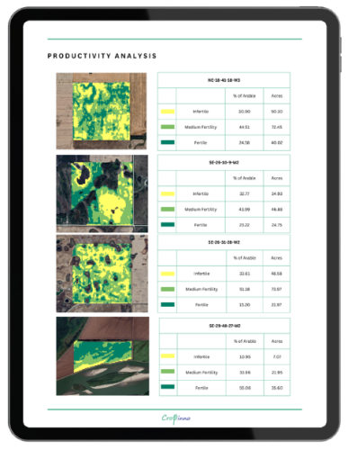
Evaluate the land’s agricultural output using vegetation indices. Our analysis includes historical productivity trends, yield estimates, and crop health monitoring, offering valuable insights into the land’s long-term value.
Support appraisers with precise data to enhance farmland valuation reports.
Provide buyers and sellers with detailed insights for informed negotiations.
Assist lenders in determining accurate collateral values for agricultural properties.
Enable investors and insurers to assess risks associated with farmland investments.
Equip yourself with the data and tools you need to excel in the farm valuation industry. With Cropinno’s Agricultural Appraisal Service, you can deliver precise valuations, mitigate risks, and make smarter decisions.
about how we can support your appraisal and valuation needs
Copyright © 2025, Cropinno Inc.